• Skip to main content
  • Skip to primary sidebar

An American Songline

Journeys in Vintage Music with Cecelia Otto

  • About
    • An American Songline
    • Cece’s Story
    • Accolades & Press
  • The Programs
    • Prohibition
    • Centennial of Suffrage
    • The History of Early American Song
    • A Celebration of America
    • A Musical Journey Along the Lincoln Highway
    • The Songs of World War I
    • Video
    • FAQ
  • Shows
    • Current Tour & Show Dates
    • Book Cece
    • Testimonials
  • Blog
  • Store
  • Contact
    • Get Updates
    • Press Kit
    • Get Crowdfunding Support

Ft. McPherson

Kearney to North Platte: Exploring more of Central Nebraska

July 28, 2013 by Cece

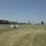
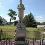
As I left Kearney, NE on the morning of July 4th, the road changed for me yet again. This time the road had a different buzz then before. The big centennial celebrations were over, but because of the holiday nothing had been taken down yet. Town still kept various things open not only for the holiday, but for Lincoln Highway travelers like myself. In one of my previous posts, I remarked about what the route looked like in advance of the car tours. Would everything go back to the way it was, or would it all stay up for the rest of the summer? Would the Lincoln still be prominent in people’s minds, or would it fade away again? I’d have to drive further down the road to see what happened…

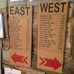
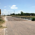
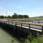
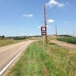
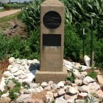
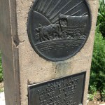
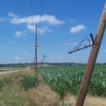
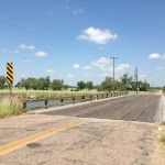
It’s about 100 miles as the crow files from Kearney to North Platte, but in these parts it takes a lot longer to get there than one would think thanks to the famous “Stair Steps” along the route. If you drive US 30 in this part, you are NOT driving on the original highway. When the Lincoln was being plotted 100 years ago, it was tricky in those days to get across the South Platte River. They used the existing roads of the time, which followed section lines around farms. These lines formed a stair step pattern when you looked at a map. You can read more about this part of the route here. It winds and curves, dozens of times, but it a beautiful and historic stretch of road. Thanks to the efforts of Muriel Clark with Nebraska Outback (more about her in my next post), this section of the road now has signage directing you along all of these twists and turns. When I was photographing the road they were in process of getting all of the signs up, so it should now (as of today’s date) be fully marked.

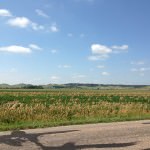
Because I had to be in North Platte at a specific time, I had to drive this section on two different days. I followed the original route until Gothenburg on the 4th, and then I came back and drove the original route from Gothenburg to North Platte a few days later. I really loved driving this part of the route, and I’m glad I took the time to see it.

About four miles west of Kearney is the famous covered wagon being pulled by two oxen. It was a souvenir stand along the highway for many years. The adjacent building is being renovated into a multipurpose building.
The Overton bridge shows where the original highway alignment used to be.
The bridge has been freshly painted, and it looks great!
The city of Cozad Nebraska marks the place where the 100th meridian intersects with the routes of the Oregon Trail, Pony Express, transcontinental railroad, and the Lincoln Highway.
Gothenburg’s Pony Express Station is a really nice authentic stop to get a little history and a bottle of water!
Here’s an interior view of the cabin.
These signs show how many miles to various cities around the US.
This is the beginning of the Gothenburg Steps south of the city.
You can see the change in pavement in this shot.
Near Brady, NE you can find Conroy’s Grave. It reads: “A. Conroy Sept. 1868 Killed by the Sioux while mowing hay For the government troops”
This soldier marks where the original Ft. McPherson once stood. This statue was put in its place in 1928.
Fort McPherson National Cemetery is located along the original Lincoln Highway route. It was first started in 1863.
Grave #1 at Fort McPherson.
Child who died at the Fort.
Another beautiful tribute to a soldier.
You can see in this detail how this person died.
This Monument commemorates the men killed in an 1854 massacre.
You’ll see that there are musicians among the dead from this massacre.
After I left Ft. McPherson, I finally started to see the Lincoln Highway signs!
Pony Express Marker along the route.
Another great old bridge along the Lincoln, this time I felt safer going across this one.
Detail of bridge.
Here’s another Gothenburg Stair Step sign, noting the curve this time.
There were several Oregon Trail Markers along the road , but this one is in excellent condition.
Here’s some detail in the marker.
You saw old and new phone poles coexisting along the route in many places.
I thought I’d leave you all with this parting shot. I can’t wait to see what lies down the road!

Filed Under: Driving, Nebraska, Odds and Ends Tagged With: Brady, Conroy's Grave, Ft. McPherson, Gothenburg, Lincoln Highway, Muriel Clark, Nebraska, Nebraska Outback, Oregon Trail, Pony Express, Stair Steps, The Old West

Primary Sidebar

Follow Cece’s American Songline Journey

Relive the Struggle for Women’s Rights

An American Songline: Centennial of Suffrage is now available to purchase, featuring lyrics for 14 suffrage anthems, as well as Cecelia Otto's notes and commentary..

PURCHASE NOW »

Upcoming Tour & Show Dates

Come see Cece perform live! See if she’ll be performing near you in the near future.

SEE CECE LIVE »
  • Dribbble
  • Facebook
  • Instagram
  • LinkedIn
  • Pinterest
  • Twitter

Copyright © 2023 — An American Songline • All rights reserved.

Log in